


De Génicourt à la forêt de Rosnes

flzanichelli
User
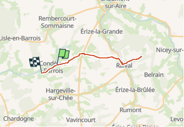

Length
21 km

Max alt
332 m

Uphill gradient
274 m
Km-Effort
25 km

Min alt
206 m

Downhill gradient
295 m
Boucle
No
Creation date :
2024-05-20 09:25:10.616
Updated on :
2024-05-20 10:54:03.015
1h28
Difficulty : Very easy

FREE GPS app for hiking
 SityTrail
IGN / Geographical institutes
SityTrail Plus
The world is yours!
About
Trail Electric bike of 21 km to be discovered at Grand Est, Meuse, Les Hauts-de-Chée. This trail is proposed by flzanichelli.
Positioning
Country:
France
Region :
Grand Est
Department/Province :
Meuse
Municipality :
Les Hauts-de-Chée
Location:
Unknown
Start:(Dec)
Start:(UTM)
659694 ; 5415430 (31U) N.
Comments